Nortantis Updates (Version 3.20)
This release introduces a big feature I’ve been wanting to create for some time - sub-maps, as well as a second significant project - freehand river drawing. Beyond those, there's a large batch of UI improvements and bug fixes, and a Fedora installer.
Sub-maps
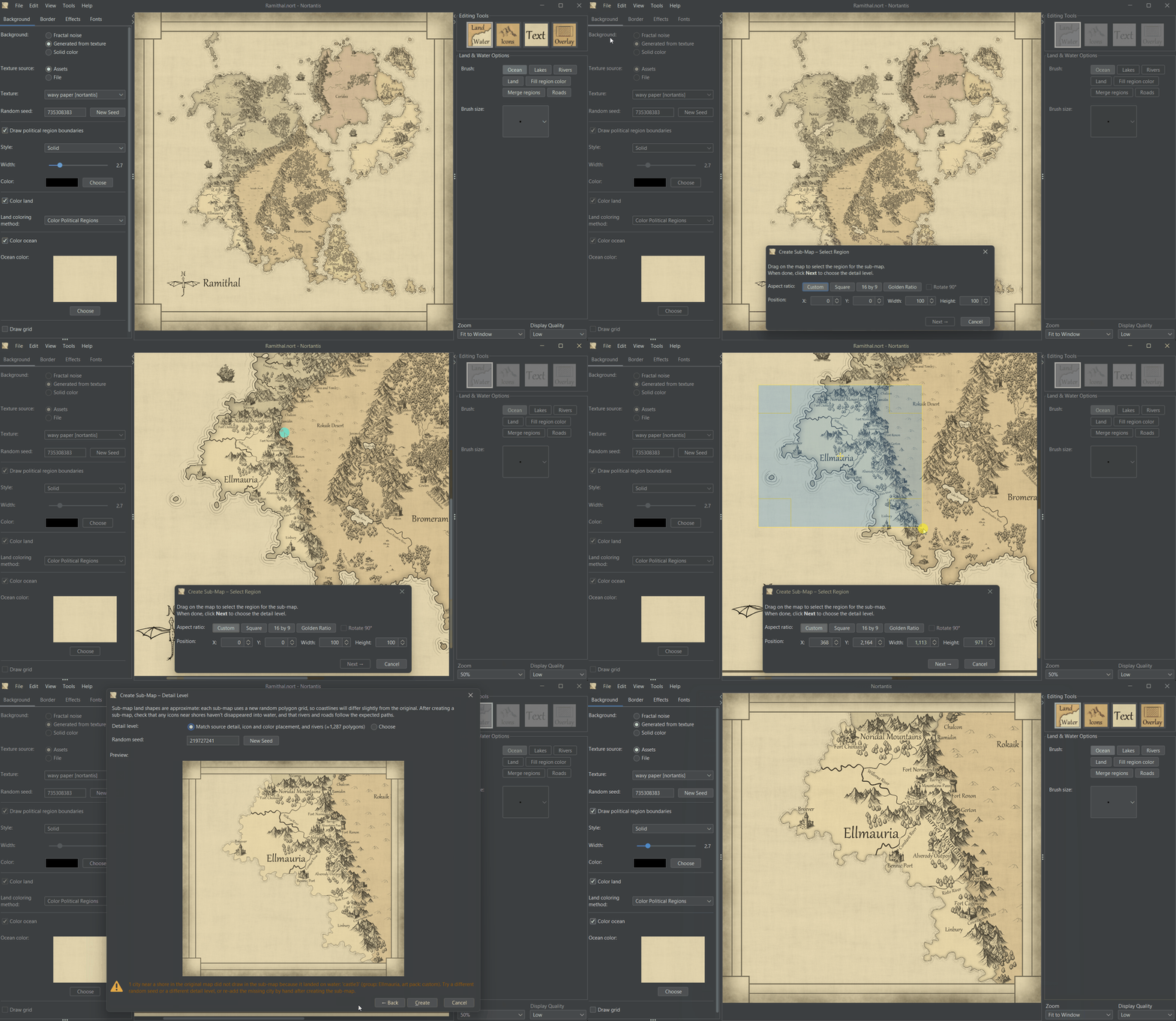
The new sub-map feature allows you to create a new, independent map from a selected area on another map. The created sub-map has its own polygon grid and saves as a separate nort file.
The selected region can be selected free-hand or constrained to a desired aspect ratio.
Detail level - you can either choose to match the detail level of the source map, which will give the closest fidelity to the source map, or you can select the option to choose a detail level, which allows you to use whatever world size you wish. With the second option, icons and rivers are redistributed onto the new grid instead of copied over, and those, along with text, will be sized according to the detail level.
Since the sub-map uses a new polygon grid and coastlines and region boundaries always follow grid polygons, of necessity, the coastlines and region boundaries will shift a little in sub-maps. Watch closely to make sure cities or other important landmarks drawn near coastlines don't disappear, and islands or isthmuses maintain the desired shape. Check your rivers and roads to make sure they look good. The "New Seed" button on step 2 of the sub-map wizard can be useful to try different seeds to get a sub-map that closely reflects the original selection. If a city disappears into water in the sub-map because of the coastline shifting, the wizard will give you a warning.
If you ever want to recreate a sub-map, the sub-map’s nort file has all the information needed (assuming you still have the original map too). Just go to Help → Map Info.
Free-hand River Drawing
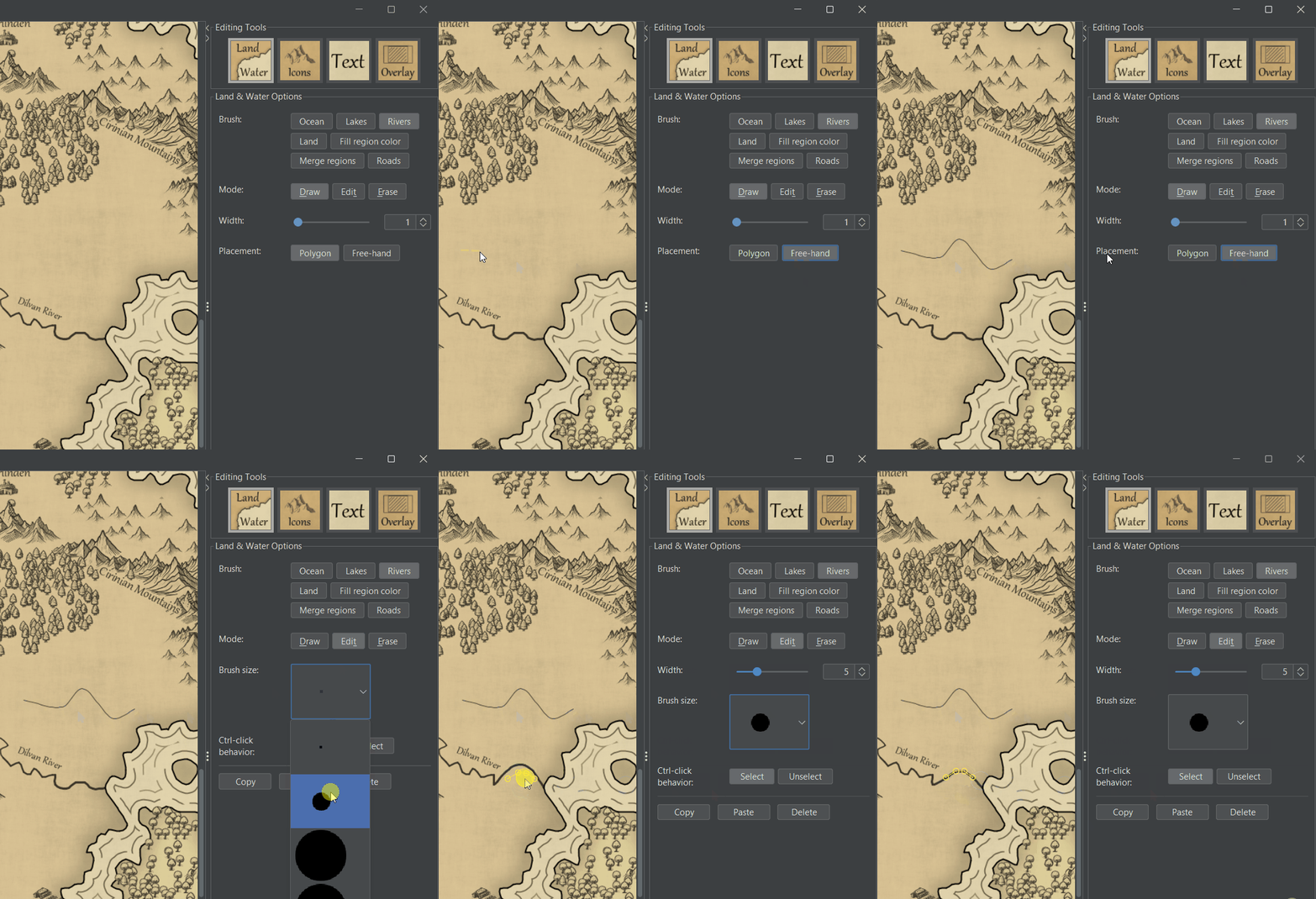
Previously, rivers always followed polygon edges on the graph. While working on the sub-map feature, I realized I really needed a way to directly copy rivers from the source map for the "match source detail" mode, which meant the editor needed more flexibility for rivers. Roads already had the ability to draw freehand, and users have asked for that ability with rivers too, so I decided this was a good time to add it. It, eh, ended up being a little more work than I expected, but here it is!
Rivers are drawn using control points that can be added, moved, and deleted.
Previously, rivers that followed region boundaries reshaped the boundary to the river and replaced the boundary line. That feature still works, but to use it, you must use "Polygon" placement.
The new Edit mode for rivers allows changing the width of existing rivers, so you no longer have to redraw them to change their width. And as a bonus, you can tell the width of a river segment by selecting it in edit mode.
Ctrl-click, larger brush sizes, or dragging to select allows selecting and editing multiple rivers or road segments simultaneously.
Expanded Copy-Paste Options and Right-Click Menus
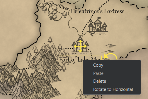
Copy-paste now works for more than just icons. It can also be used for rivers, roads, and text. Additionally, I've added delete options for these objects in edit mode, so you don't have to switch to erase mode every time you want to delete something. All of these options are included in new right-click menus as well. Erase mode still exists for ease of use when deleting a lot of objects.
Missing Art Pack Handling
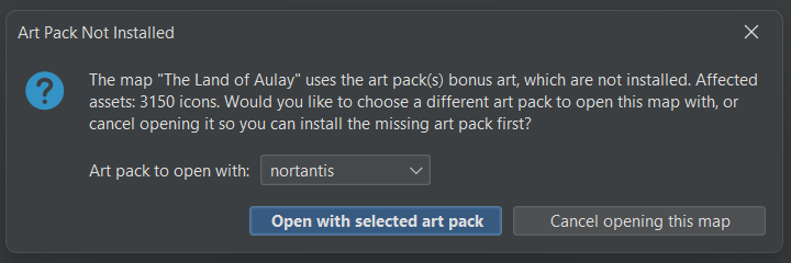
When you open a map that references an art pack you don’t have installed, instead of choosing a different art pack automatically and substituting all your icons without asking, you now get a popup listing which art pack(s) are missing and what they affect (border, background texture, and/or a number of icons), with the option to choose another art pack or cancel opening the map.
Warning When Cities Disappear in Water
Nortantis does not allow most icon types, including cities, to be drawn on oceans or lakes. That creates some friction because if you change the "Line style" or "City size" in the left panel (under Effects), a city previously by a shore might end up trying to draw over water and end up being removed. To make matters worse, there was also a bug (that has existed for years) where changing the display quality could cause cities to disappear if they were within approximately one pixel of water because the water hit testing was pixel-based.
Now, the hit testing is done using vector-based geometry, so it doesn't depend on the resolution or display quality. Also, changes that cause cities to inadvertently disappear into water trigger a popup warning telling you how many cities were lost. Edit → Undo can bring them back.
The display quality fix makes the water hit testing more accurate, but because of that change, it is possible, although unlikely, that simply opening a map from version 3.18 or earlier will cause a city to disappear. If that happens, it will also trigger a warning popup. Unfortunately, your best option at that point for getting your cities back is to compare the map to a previously exported version and then add the cities back by hand. If you don't have a previous export, you can close the map without saving and export it using Nortantis version 3.18 (assuming you still have the installer; ask me if you need one).
Zoom, Pan, and Navigation
Fixed touchpad zooming being too fast/twitchy compared to mouse-wheel zooming.
Added keyboard shortcuts for zooming in/out.
As always, you can look these things up using Help → Keyboard Shortcuts.
Other Fixes
General UI Fixes and Improvements
The map draw progress bar is now determinate (shows real progress) instead of bouncing back and forth.
Many fixes for macOS, and fixes to the macOS installer creation script.
Fixed a bug where selecting English in the app only worked if your OS locale was already set to English.
Added a support request on the startup screen and About dialog, with a checkbox to dismiss it on startup.
Links to the project page and related pages on the startup screen.
Help → Map Info isn’t just for sub-maps. Non-submaps also use it to show information about the map, such as dimensions and world size.
Nortantis now remembers its window size and position when you close and re-open it. To reset to the default size and reset side-panels, I added View → Reset Window Layout.
Rendering Fixes
Fixed rare visual tearing/seams in concentric wave patterns and in incremental (in-progress) map updates.
Fixed small hook-shaped overshoots at the ends of concentric wave-line curves.
Fixed occasional bright spots on low-resolution maps with certain background textures.
Fixed ocean ripple waves producing dark patterns instead of ripples when wave width was set very low on a low-resolution map.
Fixed land color bleeding across polygon edges near the map border.
Fixed a handful of stale-pixel edge cases in incremental redraws, including two-line text, letter-spacing click-target alignment, and a one-pixel strip at the map's right/bottom edge after an incremental edit.
Linux
Added a Fedora RPM installer alongside the existing Debian/Ubuntu and Arch Linux packages.
Attempted Flatpak packaging but ended up dropping it because of UI display quality issues.
Fixed Nautilus icons for nort files not appearing on Ubuntu.